Israel would be exposed to grave perils if an Arab state were ever to be established on the commanding hills overlooking the country’s coastal megalopolis.

“If a Palestinian state is established, it will be armed to the teeth. Within it, there will be bases of the most extreme terrorist forces, equipped with anti-tank and anti-aircraft shoulder-launched rockets, which will endanger not only random passers-by, but every airplane and helicopter taking off in the skies of Israel and every vehicle traveling along the major traffic routes in the coastal plain”
The above warning was issued by none other than Nobel laureate, the late Shimon Peres, in his book “Tomorrow is Now” (pp. 232, 255.)
After all, “Palestinian” statehood and a secure Israel are mutually exclusive goals. Indeed, this was always the accepted wisdom in Israel – until the discourse was hijacked by the tyrannical diktats of politically correct dogma.
The above dour caveat was echoed by Israel Prize laureate, Prof. Amnon Rubinstein, who also served as Education Minister on behalf of the far-Left Meretz faction: “…Israel, small and exposed, will neither be able to exist nor prosper if its urban centers [and] its vulnerable airport…are shelled…this is the terrible danger involved in the establishment of a third independent sovereign state between us and the Jordan River. – ‘The Pitfall of a Third State’, Haaretz, Aug. 8, 1976.
These two citations convey, with chilling accuracy, the grave perils to which Israel would be exposed if an Arab state were ever established on the commanding hills overlooking the country’s coastal megalopolis, where about 80% of the country’s civilian population and commercial activity are located.
These dangers are dramatically illustrated by the following series of photographs, shot from locations inside the territory designated for any future Arab state.
A Tempting Target: Israel’s Coastal Urban Sprawl
The following photographs convey starkly what a tempting target the office buildings, prestigious apartment blocks, teeming recreational and entertainment centers and central transport arteries (rail and road) would be if the IDF were to evacuate areas earmarked for a future Arab state.
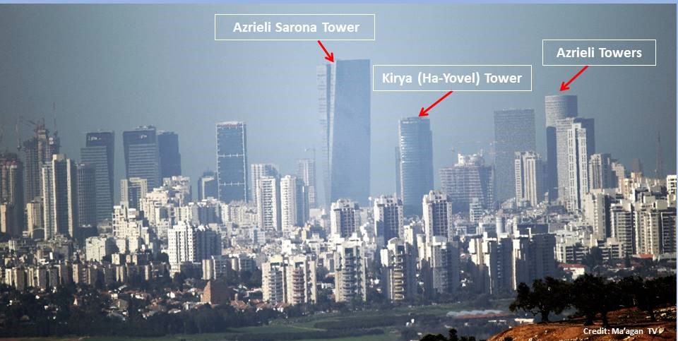
Above: Tel Aviv skyline showing the iconic Azrieli high-rise complex, adjacent to the Ministry of Defense and IDF’s GHQ, the trans-Tel Aviv Ayalon Highway and the busy HaShalom railway station; also seen is Kirya (Ha-Yovel) Tower, with 28 of its 42 floors occupied by government offices, and the nearby Azrieli Sarona Tower, the tallest building in Tel Aviv – as seen from just east of the Arab villages of Rantis & Al-Lubban.
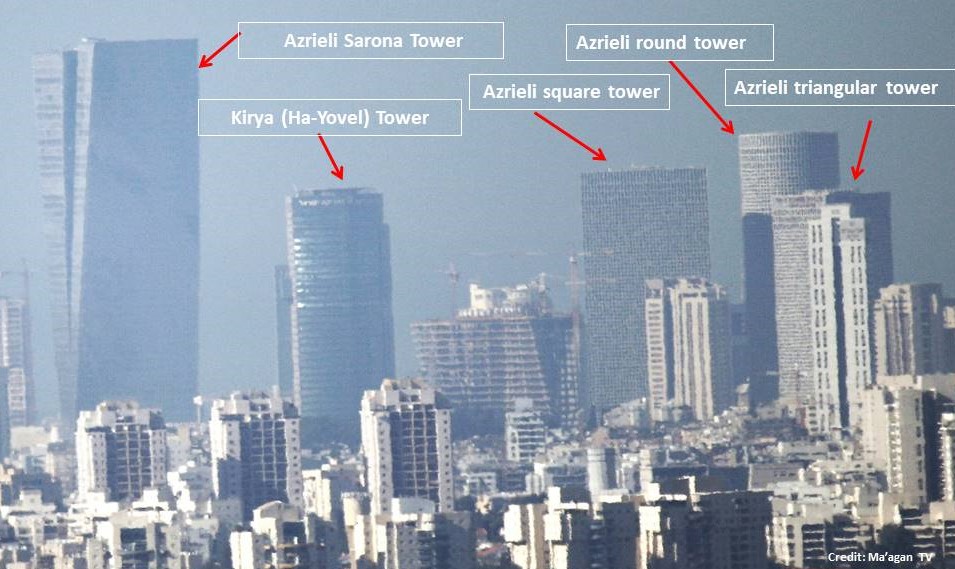
Above-Enlarged: The Azrieli high-rise complex, adjacent to the Ministry of Defense and IDF’s GHQ, the trans-Tel Aviv Ayalon Highway and the busy HaShalom railway station; also the Kirya (Ha-Yovel) Tower, with 28 of its 42 floors occupied by government offices, & the Azrieli Sarona Tower, the tallest building in Tel Aviv.

Above: Tel Aviv skyline showing the luxury apartment complex, Park Tsameret, adjacent to the trans-Tel Aviv (Ayalon) highway and the busy Savidor Central railway station – as seen from just east of the Arab villages of Rantis and Al-Lubban.

Above: Enlarged: North Tel Aviv skyline showing the luxury apartment complex, Park Tsameret, adjacent to the trans-Tel Aviv (Ayalon) highway and the busy Savidor Central railway station.
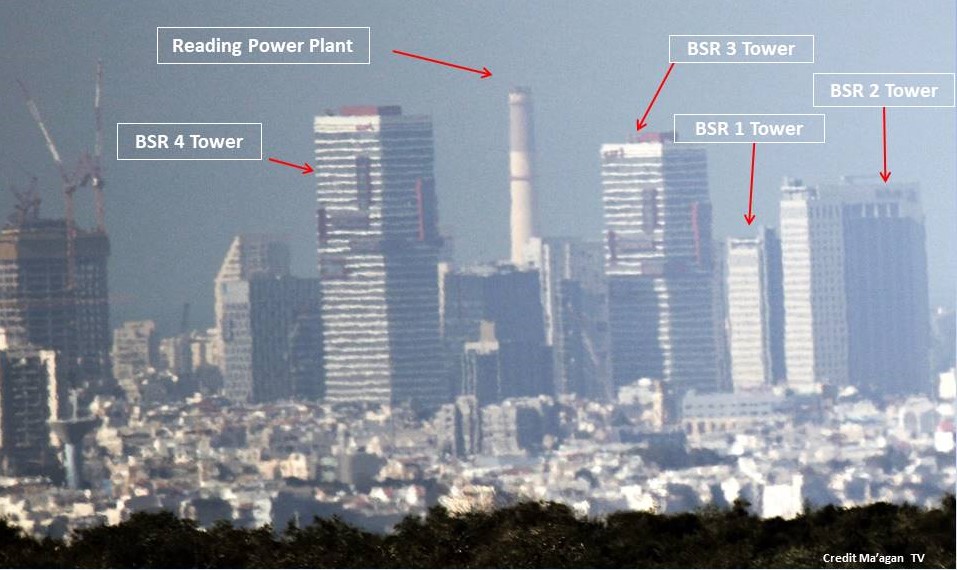
Above: North Tel Aviv, Ramat Gan, Bnei Brak sky-line showing the Reading Power Station chimney, adjacent to the Tel Aviv Port recreation area, and the 4 BSR Towers, which house many upmarket law firms, medical facilities, hi-tech offices and numerous busy restaurants– as seen from just east of the Arab villages of Rantis & Al-Lubban.
Ben Gurion Airport Hopelessly Exposed
The following four photographs depict how utterly exposed the installations and aircraft – both on the ground and in the sky – would be to any hostile forces–even lightly armed–deployed on the highlands east of Israel’s densely populated coastal plain.
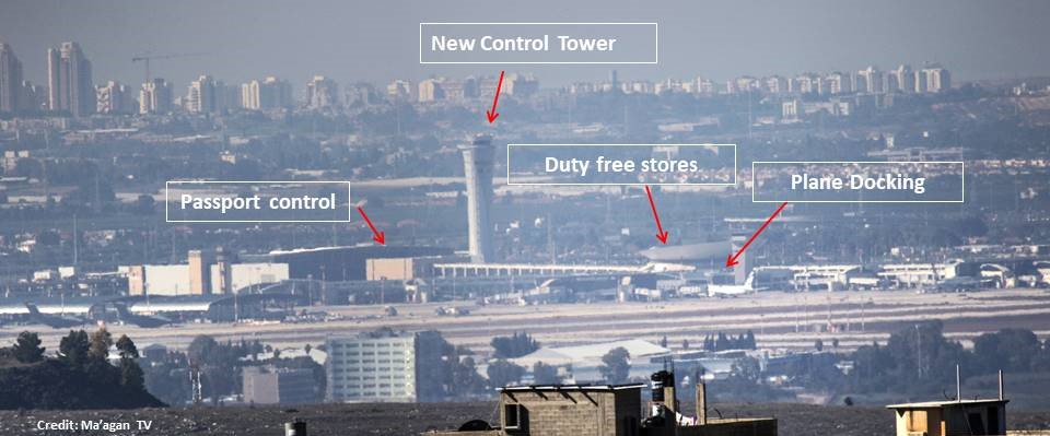
Above: Israel’s main international airport, Ben Gurion – as seen from just east of the Arab villages of Rantis and Al-Lubban (buildings seen in foreground), showing the new control tower, the passenger terminal, the duty-free area and planes docking for embarkation/disembarkation.
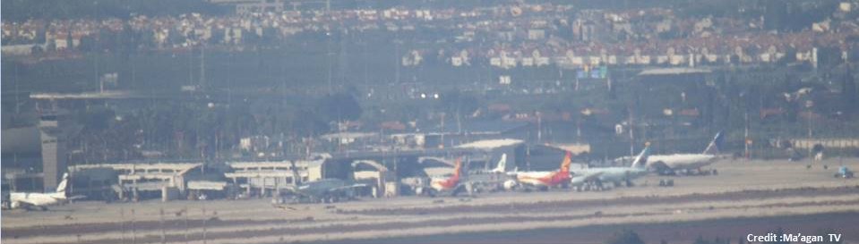
Above: Israel’s main international airport, Ben Gurion – as seen from just east of the Arab villages of Rantis and Al-Lubban showing numerous civilian planes on the tarmac.
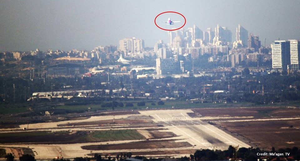
Above: A plane taking off from Ben Gurion – as seen from just east of the villages of Rantis and Al-Lubban.

Above: Arkia airliner taking off from Ben Gurion airport – shot from just east of the Arab villages of Rantis and Al-Lubban. (Camera: Canon 7D Mark II with Sigma Sport 150/600 lens).
The Imperative to “Think Ahead”
Israel must think ahead as to what the consequences of any territorial concessions may be. One of the possibilities Israel should prepare for is the (highly plausible) prospect that any land vacated by Israel and the IDF will fall into the hands of vehemently hostile elements – as happened every time Israel has relinquished territory to Arab control—whether in the North in South Lebanon; in the South in the Gaza Strip, and even in Sinai, now descending into the depravity of Jihadi brutality.
 Of course, once Israel evacuates the strategically vital highlands of Judea-Samaria to facilitate the establishment of a Arab state, there is no way that Israel can have “secure and defensible borders”—for there is no way it can ensure that they will not fall into the very hands of those who seek its destruction, including elements controlled by the terror “puppet masters” in Tehran.
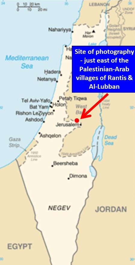
(All photos taken on January 31, 2018, using a Canon 7D Mark II camera, fitted with a Sigma Sport 150/600 lens, from just east of the PA Arab villages of Rantis and Al-Lubban, located about 5 km across the pre-1967 “Green Line” (see map), they vividly convey how vulnerable and exposed Israel would appear through the binoculars of any Arab “intelligence officer” (a.k.a. terrorist) perched on those heights.)
____________________
Martin Sherman is the founder and executive director of the Israel Institute for Strategic Studies.
[Find this article interesting? You can find more in depth articles on Israel and the Middle East @en.mida.org.il]


[…] MIDA: http://en.mida.org.il/2018/03/11/arab-palestine-safe-israel-mutually-exclusive/ MEDIUM: […]